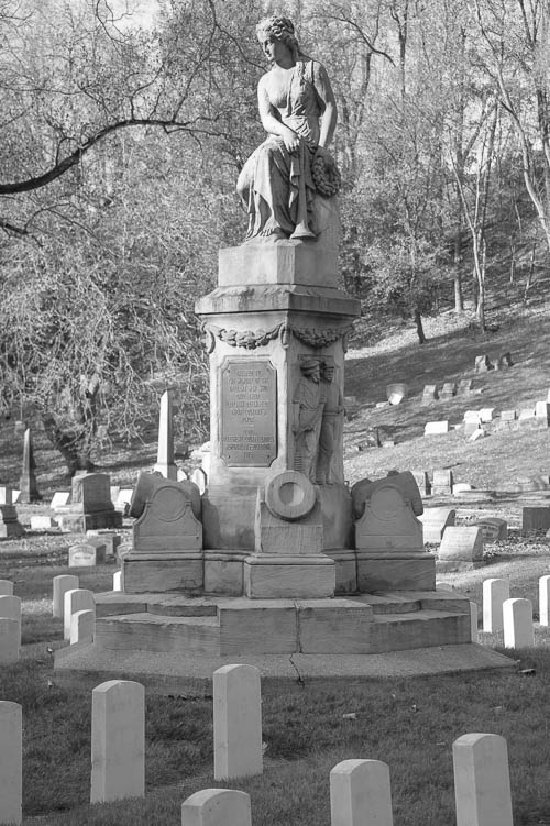
In 2018, I took a guided tour of Allegheny Cemetery. This cemetery is on the National Register of Historic places.
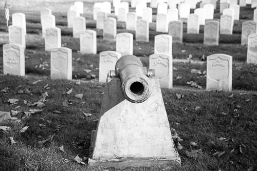
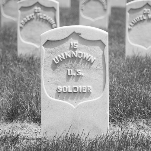
Allegheny Cemetery includes a National Cemetery Administration’s soldiers’ lot. The Allegheny Cemetery Soldiers’ Lot is located in Section 33 of Allegheny Cemetery. The majority of the 303 soldiers buried here were Civil War soldiers. Most of the burials were of Union soldiers; however, the lot also contains several Confederate soldiers.
I returned to the Soldiers’ Lot in 2019 in order to take some photos.
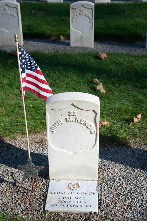
I didn’t have any prior knowledge of this following soldier, but I Googled his name when I returned home.
From the Veterans Affairs / website for Allegheny Cemetery Soldiers’ Lot: Corporal John M. Kendig (Civil War). He received the Medal of Honor while serving in the U.S. Army, Company A, 63rd Pennsylvania Infantry, for actions at Spotsylvania, Virginia, May 12, 1864. His citation was awarded under the name of Kindig. He died in 1869 and is buried in Section 33, Lot 66, Site 32.
I own a signed copy of Pittsburgh: The Story of An American City, written by Stefan Lorant with several contributors. I purchased it for $5 from a used bookstore. The book came apart in several places at the binding. The book contains almost seven hundred pages of Pittsburgh history and photos.
This book’s Chapter 3 The City Grows by Oscar Handlin includes a sidebar titled Pittsburgh in the News. This sidebar includes the following item:
“Joe Barker, a colorful street preacher, was arrested in 1849 when he was involved in a riot while delivering one of his many tirades against Catholicism. He was thrown into jail and while in prison he was elected as mayor of the city. After serving for one year he was defeated for re-election and sank into obscurity. He died in 1862 when run over by a train.“
(Wikipedia taught me that the train decapitated Mayor Joseph Barker. He is buried in Allegheny Cemetery.)
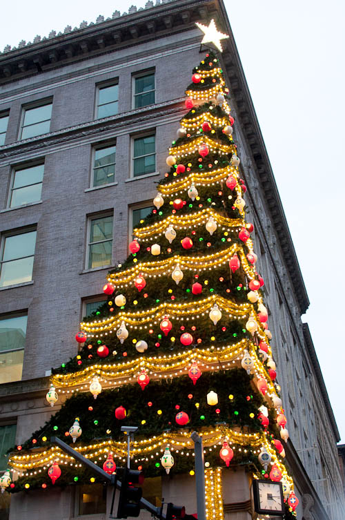
Horne’s Department Store. Pittsburgh, PA. December 28, 2015. (Photo: Jenny Gaffron Woytek)
Pittsburgh had a department store chain called Joseph Horne’s, or Horne’s Department Store, or simply Horne’s.
An electric Christmas tree decorated the building’s corner each holiday shopping season.
Horne’s merged with another chain in 1994. Then, the building which housed Horne’s downtown flagship store became offices for an insurance company (Highmark).
However, this tree still graces the building each year from the week before Thanksgiving until New Year’s.
Here is a photo of the building and its tree.
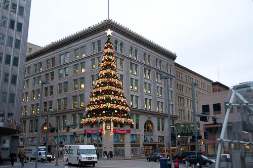
Horne’s Department Store. Pittsburgh, PA. December 18, 2014. (Photo: Jenny Gaffron Woytek)
Everything that I know about Horne’s Department Store came from “American Elegy: A Family Memoir” by Jeffrey Simpson. This particular book detailed the author’s family’s experiences in Parnassus, a sort-of Pittsburgh suburb. In the Chapter titled “Parties (Quint and Ruby),” the author wrote the following about his step-grandmother Ruby’s affinity for shopping at the downtown Pittsburgh Horne’s:
When my mother and Ruby were young women in the late 1920s and 1930s, there was a lounge on Horne’s mezzanine where you could wait for friends. The lounge had a book in which you could leave messages for your chums if you had to leave early or had dashed up to Lingerie for a quick purchase while you were waiting; it was an amenity that seemed to belong to a period of orange minks and nose-tip veils, when girls fresh from college, eager with their first salaries, met “in town” for lunch on Saturday.
Simpson wrote that Ruby grew up “poor” and thus as soon as she received her first very own paycheck, she spent it at Horne’s. Ruby referred to Horne’s as the “good” store. She relished the chance to be seen shopping there. Simpson noted that the Parnassus community and Ruby herself thought that Ruby had married up (to a widower with a good family and a good job). That Ruby’s clothes, purchased from Horne’s, helped her to achieve this marriage.
Simpson concluded:
The Horne’s boxes, cream-colored pasteboard with Jos. Horne Co. in light, bright blue on the lid, represented for Ruby the life she had made for herself.
My own maternal great-grandma worked for Horne’s. However, I don’t have any stories about her retail career.
I myself work directly across the street from the old downtown Horne’s building. I never shopped for clothes there. I grew up in rural Pennsylvania. I started working in Pittsburgh years after Horne’s closed.
When I interviewed for my job, the building housed an Old Navy store.
By the time that I started my job, the Old Navy was a Rite Aid.
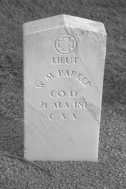
I took this at the Allegheny Cemetery Soldiers’ Lot, Lawrenceville, Pittsburgh, PA. This headstone marks the grave of a Confederate soldier from the American Civil War. (C.S.A. stands for “Confederate States of America.”)
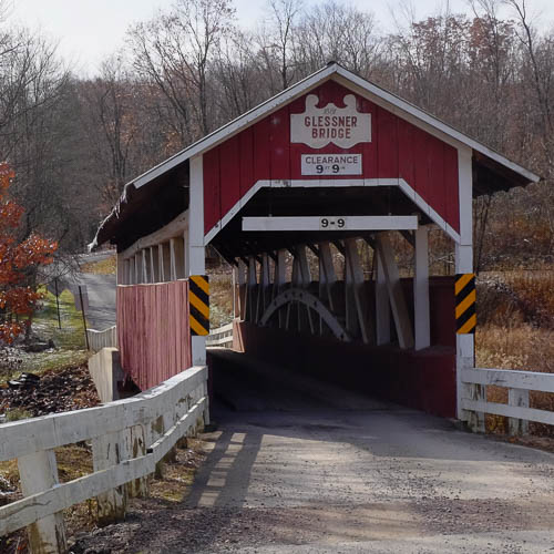
Glessner Bridge, Somerset County, PA. November 9, 2019. (Photo: Jenny Gaffron Woytek)
I visit the Flight 93 National Memorial during some trips to my hometown of Berlin, PA. I travel from Berlin to the memorial on a series of back roads. (These roads are a much more direct way for me than the posted route on U.S. 30 / Lincoln Highway.)
On each trip, I pass signs for the Glessner Bridge. Tobias Glessner built this bridge in 1881. The bridge sits on the National Register of Historic Places.
Only five miles separates the Glessner Bridge from the Flight 93 National Memorial.
I visited the bridge last weekend.
If you visit the bridge, be mindful that you will leave the “main drag” of Route 30. You will travel past working farms. Last week, I had to slow down for chickens on the road. I also saw an Amish buggy. In other words, PAY ATTENTION as you drive. STAY OFF OF YOUR PHONE.
(Sidenote: Both my mother and my mother-in-law lived in rural Pennsylvania at points in their lives. Both women told stories of having to stop their cars for cows sitting in the middle of various farm roads. It happens.)
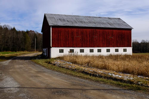
Also, here’s the barn that sits next to the bridge.
Red Barn, Somerset County, PA. November 9, 2019. (Photo: Jenny Gaffron Woytek)
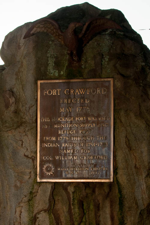
The Massy Harbison Chapter of the DAR (Daughters of the American Revolution) dedicated this monument to Colonel William Crawford in Parnassus, New Kensington, PA, in 1943. Photo dated October, 2019. (Photo: Jenny Gaffron Woytek)
Edited February 1, 2022:
I just learned that Parnassus (in New Kensington, PA) shares a historical figure with downtown Columbus, Ohio. In fact, this story even left its mark on Columbus’ current National Hockey League arena.
I discovered this from an episode of Haunted Talks – The Official Podcast of the Haunted Walk, hosted by Creative Director Jim Dean. In Episode 68 – Columbus Ghost Tours, the host interviewed the Columbus tour co-owner Bucky Cutright.
Cutright shared one ghost story from his tour – the tale of “haunted” Nationwide Arena, the home of the Columbus Blue Jackets, an NHL team. Cutright revealed that the arena was built on the parking lot for the former Ohio Penitentiary.
Cutright noted that an indigenous Mingo village (Salt-Lick Town) once stood on this entire property. He talked about the village’s destruction in 1774. He described the death toll of Mingo families, at the hands of white settlers led by a man named William Crawford.
(My knowledge of the incident in question is limited to the interpretation of this referenced tour guide operator. I have no knowledge of the tour operator’s research methods.)
“Wait a minute,” I thought. “Our William Crawford?“
See, I live in the Parnassus neighborhood in New Kensington, Pennsylvania. Parnassus emerged from the remains of Fort Crawford, at the confluence of Pucketa Creek and the Allegheny River.
Colonel William Crawford’s troops in the Continental Army built Fort Crawford in 1777. This was during the American Revolutionary War. Crawford previously fought with the British in the French and Indian War in the 1750’s. Crawford survived the Battle of the Monongahela (Braddock’s Defeat) in 1755. Crawford knew George Washington!
I Googled “William Crawford” and “Columbus.” I saw the portrait of the man who led the expedition on Salt-Lick Town in present-day Columbus. This was indeed “our” William Crawford!
Now, to be clear, I do realize that William Crawford doesn’t “belong” to New Kensington. Crawford was born in Virginia. Connellsville, PA, reconstructed his Pennsylvania log cabin. Crawford County, PA, was named after William Crawford. Crawford County, OH, was also named after William Crawford.
(Edited February 1, 2023 to clarify: Colonel Crawford was involved with multiple controversies. His legacy has now extended to lore and historical fiction. See my above note that he is now apparently the subject of a tale in a ghost story tour in Colunbus, Ohio. He also appears in a historical fiction novel that I reference later in this blog post.)
For instance, Crawford was involved in Lord Dunmore’s War. The Heinz History Center in Pittsburgh has an exhibit about this.
Let me tell you a little bit about how Colonel William Crawford died.
The American Revolutionary War ended in 1783. However, in the years before this, the settlers in colonial Pennsylvania and Ohio fought the British and they also fought assorted Native American communities. The settlers killed Native Americans, and the Native Americans killed settlers.
(The Heinz History Center, which was linked above, is an excellent resource about this historical period. The following is a very, very stripped down story about Simon Girty’s alleged role in the death of Colonel Crawford.)
During this time period, Simon Girty, a white guide who was raised by Native Americans, defected to the British and their Native American allies. Prior to the defection, Girty operated out of Fort Pitt as a “home base.” Girty’s defection to the British was a controversial event in Western Pennsylvania. Girty fled to Ohio. I invite you to read the resources available through the Heinz History Center for a more in-depth discussion about Simon Girty.
Then, in 1782, Crawford led the Crawford Expedition against Native American villages along the Sandusky River in Ohio. These Native Americans and their British allies in Detroit found out about the expedition. They ambushed Crawford and his men. These Native Americans and the British troops defeated Crawford and his militiamen.
A force of Lenape and Wyandot warriors captured Crawford. They tortured Crawford. They executed him by burning him on June 11, 1782.
Simon Girty was there, at William Crawford’s execution.
In fact, witnesses alleged that Girty “egged on” Crawford’s captors as they tortured him. Witnesses even alleged that Crawford begged Girty to shoot him as he burned alive, and that Girty laughed at Crawford.
Girty denied that he encouraged the warriors who tortured Crawford.
Girty settled in Detroit, among the British. Years later, Detroit became part of the United States and Girty fled to Canada. At least one internet source listed Girty as a Canadian historical figure. I learned that Girty’s name appears on an Ontario memorial for “Loyalists” (to the British Crown).
The Pennsylvania Historical and Museum Commission (PHMC) dedicated at least two plaques in Girty’s memory. (To my knowledge, the PHMC dedicated one plaque to Girty in Pittsburgh (near the Waterfront shopping district) and another plaque to Girty along the Susquehanna River in the Harrisburg area. This second plaque commemorates Girty’s birthplace in Perry County.
Now, Hannastown was the first county seat of Westmoreland County, PA. I read that the town lost a significant portion of its able-bodied fighting men in the Crawford Expedition. On July 13, 1782, Seneca warrior Guyasuta and his men burned Hannastown and its crops. Greensburg became the county seat after this.
If you want to read historical fiction in which William Crawford and Simon Girty appear together, then I suggest “The Day Must Dawn” by Agnes Sligh Turnbull.
(Postscript, 09/16/20: Per the photo at the top of this blog post, there is a monument to Fort Crawford and to Colonel William Crawford in Parnassus in New Kensington. The Daughters of the American Revolution dedicated it in 1943.)
My husband told me that his history teacher at a Catholic high school (who I think was an elderly nun) planned for her students to watch Monty Python historical parodies in class whenever she needed to keep them busy so that she could work on paperwork.
For instance, once at the end of a grading period, my husband watched “Monty Python and the Holy Grail” in his Catholic high school history class. This is how he learned about the Catholic Church’s role in the Spanish Inquisition. (Just kidding, I’m sure that the teacher also gave the REAL story about the Church’s role in the Inquisition. Hopefully.)
Another Monty Python classic is “The Life of Brian,” which is a comedy about a young man named Brian who is mistaken for Jesus Christ from birth up until his accidental crucifixion. (In case it wasn’t clear, Monty Python sketches are works of fiction.)
Anyway, to quote Monty Python in “The Life of Brian:”
“What did the Romans ever do for us?“
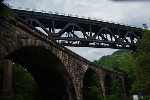
And here’s the answer: The ancient Romans engineered arch bridges.
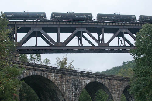
You can picnic underneath the pictured stone arch bridge at Tunnelview Historic Site in Western PA (near Saltsburg).
The Pennsylvania Railroad (PRR) built the stone arch bridge in 1907.
This bridge crosses the Conemaugh River on the side of Bow Ridge. This bridge replaced two other bridges and aqueducts at this river crossing. The bridge survived the Johnstown Flood of 1936. The Army Corps of Engineers built the Conemaugh Dam nearby in 1952 for flood control. This stone bridge no longer holds railroad tracks, but it now provides access to the dam’s east side.
The iron bridge that passes over the stone arch bridge IS a currently active railroad bridge. I took the above photo as a freight train carrying crude oil crossed the bridge and also crossed the Conemaugh River. Keep in mind that the Conemaugh feeds the Kiski River. The Kiski feeds the Allegheny River. The Allegheny feeds the Ohio River. The Ohio feeds the Mississippi River. Think about this as you watch a train full of crude oil traverse the Conemaugh.
Both of the bridges at Bow Ridge cross the Conemaugh River downstream from the dam.
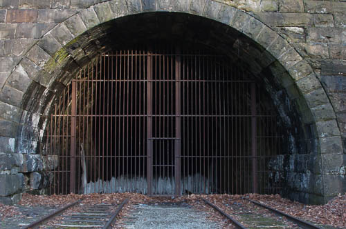
If you cross the stone arch bridge to access Bow Ridge, you will see the remains of the Bow Ridge Tunnel. The ghost town of Livermore, Pennsylvania sits beyond this tunnel, on the other side of Bow Ridge. (The government partially flooded Livermore when they built the Conemaugh Dam and created Conemaugh Lake.)
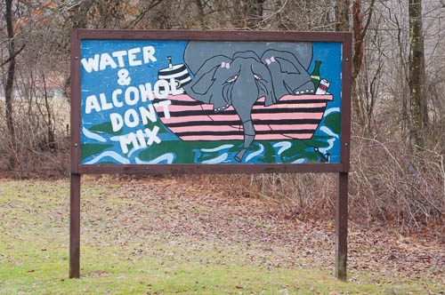
If you access the Tunnelview Historic Site through the entrance to Conemaugh Lake National Recreation Area, you will see this fantastic sign:
Drunk Elephant
Here- at the Tunnelview Historic Site – you will find a small pavilion, primitive restroom, parking lot, and canoe put-in. You will also see remains of the Pennsylvania Mainline Canal. This is where Jonathan and I put-in when we kayaked to Saltsburg twice.
Oh! I have to tell you about the FIRST time Jonathan and I kayaked from here:
We parked here at the Tunnelview Historic Site. We paddled downstream six miles, almost to Saltsburg. We stopped for lunch. It was June, and the current didn’t “seem” all that strong. As per our plan, we set off to paddle upstream back to our car.
Hey, I think that we have been paddling next to that same rock for the past ten minutes. What the – when did the current get that strong?
That’s right – we couldn’t paddle upstream. We portaged our kayaks upriver for a good part of the return trip. We smelled a dead animal rotting in the water. Jonathan didn’t tell me about the snakes that swam past us because snakes scare me. I worried that we wouldn’t get back to our car before the sun set, that we would have to spend the night in the woods, and that somebody would find our car and report us as missing on the river. As I pulled my kayak over the stones on the riverback, I fantasized about the search party that would be sent after us, about our faces all over the news. (We did get back to our car and get the kayaks loaded right before it got dark.)
In hindsight, we should have paddled to Saltsburg, then hired the canoe outfitter in Saltsburg to take us upriver to our car. We talked about doing this when we realized that we couldn’t paddle against the current. Why didn’t we? Because we’re stubborn.
On our second trip, we parked in Saltsburg and let the outfitter drive us to the put-in at the Tunnelview Historic Site. Then we paddled downriver to our car. Much better.
Life is easier when we aren’t stubborn.
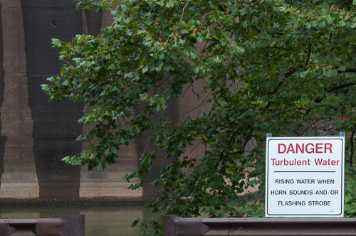
Here is the sign that SHOULD have tipped us off that the Conemaugh River’s current “might” be sorta strong at our put-in spot:
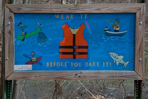
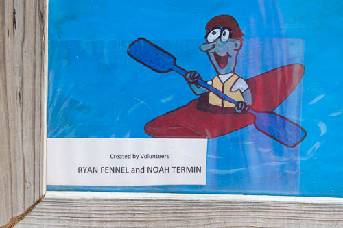
Here’s another important sign:
(Here is a close-up of the artist names:)
We haven’t picnicked at Tunnelview or kayaked on the Conemaugh River for a while because we’ve spent so much time this year with the “new” sailboat. However, I really think that you would enjoy your visit to Tunnelview.
As I noted, the remains of the canal and aqueduct at this site were part of the Pennsylvania Mainline Canal, which worked in a system with the Allegheny Portage Railroad. From the 1830’s – 1850’s, this system hauled boats over the Allegheny Mountains. Pennsylvania paid to construct the entire thing. Then, after about only two decades, the system became obsolete! I WILL blog about this on some future day.
(This is a redux from the blog that I created with my husband Jonathan, www.jennyandjonathangetmarried.com. I will shortly pull more of my favorite stories out from the crypt. I want to share more of my favorite moments and places with you fantastic readers.)
Mount Davis, Somerset County, Pennsylvania. Early 1990’s. (Photo: Shirley Katherine Gaffron)
1.) Mount Davis is the highest point in Pennsylvania.
2.) The tallest rock shown in the above photo marks Pennsylvania’s true high point. This rock includes a metal plate noting this. In the above photo, my sister K. sits at the very top of this rock.
3.) A 50 foot metal observation tower / fire tower sits a few feet away from this rock that marks the true high point.
Planning Your Trip to Mount Davis:
1.) Mount Davis belongs to Forbes State Forest. Here are the maps from PA DCNR.
2.) Jonathan and I sometimes come up here to escape Pittsburgh-area heat waves. Keep that in mind when you choose clothing for your trip.
3.) You can travel between the High Point and the Mount Davis Picnic Area by car or by foot on a CCC trail. The picnic area includes picnic tables, a pavilion, and a primitive restroom. However, note that there is no place to shop or buy gas on the summit. If you intend to travel south from Meyersdale to Mount Davis, note that Meyersdale is the closest place where you can purchase any of these things.
Watch your speed and watch out for Amish buggies. Be especially careful on Sundays. This area hosts many Amish farms, and the families who live here travel for Sunday worship. The first time that I brought Jonathan to Mount Davis, we missed the sign for our turn-off from Route 219 in our diligence regarding the buggies.