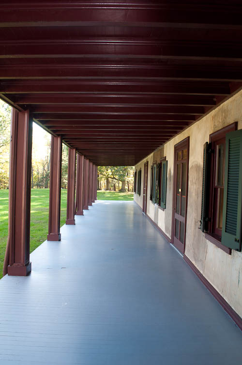
Friendship Hill, Point Marion, Pennsylvania. Photo: Jenny Gaffron Woytek
I found an article titled “Who Was Alexander Hamilton’s Real Nemesis: Aaron Burr or Albert Gallatin and the Jeffersonians?” by Christopher N. Malagisi, dated August 30, 2018, on the Townhall website. This article referenced the book “Jefferson’s Treasure: How Albert Gallatin Saved the New Nation from Debt,” by Gregory May.
The idolized and fabled Alexander Hamilton served as our first Secretary of the Treasury. Hamilton rival Albert Gallatin served as our fourth Secretary of the Treasury.
Thomas Jefferson was the President of the United States who appointed Gallatin as Secretary of the Treasury. Aaron Burr was elected as Jefferson’s Vice President in the election of 1800. So, these guys all knew each other.
Now, my brain totally shut off about one paragraph into reading about the subject matter. Just as it did when I had to learn about the Federalists and the Whigs and the Jeffersonians in high school. So, I don’t have my own fully-formed opinion about whether Albert Gallatin was Hamilton’s real nemesis. I do think that if Lin-Manuel Miranda had rewritten the Hamilton musical so that it was just a bunch of guys arguing about whether Hamilton or Gallatin made a better Secretary of the Treasury, it would not still be on Broadway.
Albert Gallatin owned an estate in Southeastern Pennsylvania. Gallatin’s first wife, Sophia, is buried on the estate. The National Park Service now runs the estate as Friendship Hill National Historic Site. There is no admission fee to visit.
Part of me wishes that Miranda had at least written Gallatin into his “Hamilton” musical – even in a tiny role – so that Point Marion could use it to lure tourists there.
If you want to sight-see while also social distancing, you may want to check out Friendship Hill. Here is my prior blog post about Friendship Hill.
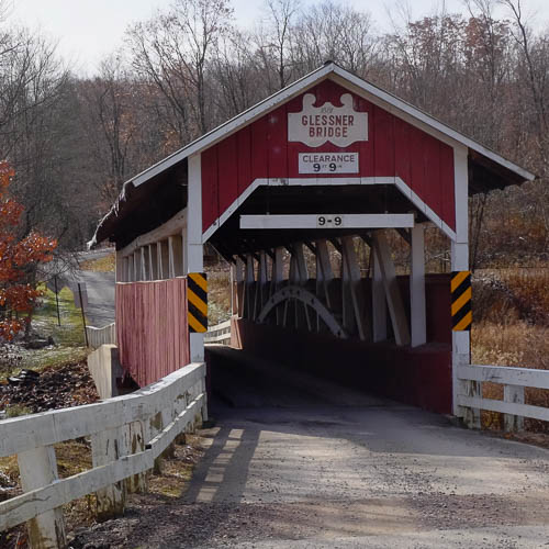
Glessner Bridge, Somerset County, PA. November 9, 2019. (Photo: Jenny Gaffron Woytek)
I visit the Flight 93 National Memorial during some trips to my hometown of Berlin, PA. I travel from Berlin to the memorial on a series of back roads. (These roads are a much more direct way for me than the posted route on U.S. 30 / Lincoln Highway.)
On each trip, I pass signs for the Glessner Bridge. Tobias Glessner built this bridge in 1881. The bridge sits on the National Register of Historic Places.
Only five miles separates the Glessner Bridge from the Flight 93 National Memorial.
I visited the bridge last weekend.
If you visit the bridge, be mindful that you will leave the “main drag” of Route 30. You will travel past working farms. Last week, I had to slow down for chickens on the road. I also saw an Amish buggy. In other words, PAY ATTENTION as you drive. STAY OFF OF YOUR PHONE.
(Sidenote: Both my mother and my mother-in-law lived in rural Pennsylvania at points in their lives. Both women told stories of having to stop their cars for cows sitting in the middle of various farm roads. It happens.)
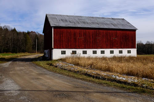
Also, here’s the barn that sits next to the bridge.
Red Barn, Somerset County, PA. November 9, 2019. (Photo: Jenny Gaffron Woytek)
And here’s the answer: The ancient Romans engineered arch bridges.
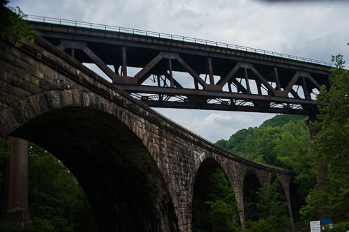
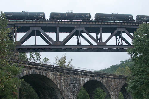
You can picnic underneath the pictured stone arch bridge at Tunnelview Historic Site in Western PA (near Saltsburg).
The Pennsylvania Railroad (PRR) built the stone arch bridge in 1907.
This bridge crosses the Conemaugh River on the side of Bow Ridge. This bridge replaced two other bridges and aqueducts at this river crossing. The bridge survived the Johnstown Flood of 1936. The Army Corps of Engineers built the Conemaugh Dam nearby in 1952 for flood control. This stone bridge no longer holds railroad tracks, but it now provides access to the dam’s east side.
The iron bridge that passes over the stone arch bridge IS a currently active railroad bridge. I took the above photo as a freight train carrying crude oil crossed the bridge and also crossed the Conemaugh River. Keep in mind that the Conemaugh feeds the Kiski River. The Kiski feeds the Allegheny River. The Allegheny feeds the Ohio River. The Ohio feeds the Mississippi River. Think about this as you watch a train full of crude oil traverse the Conemaugh.
Both of the bridges at Bow Ridge cross the Conemaugh River downstream from the dam.
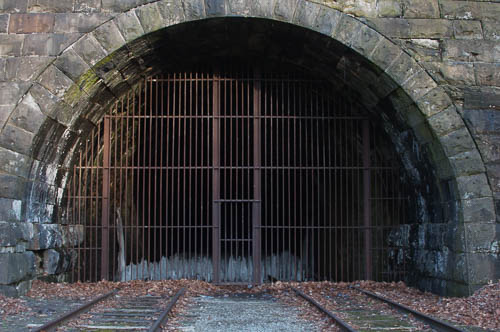
If you cross the stone arch bridge to access Bow Ridge, you will see the remains of the Bow Ridge Tunnel. The ghost town of Livermore, Pennsylvania sits beyond this tunnel, on the other side of Bow Ridge. (The government partially flooded Livermore when they built the Conemaugh Dam and created Conemaugh Lake.)
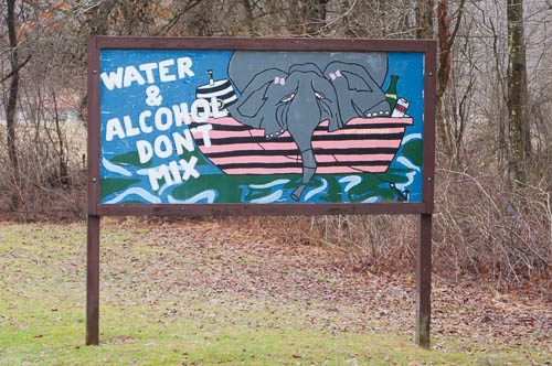
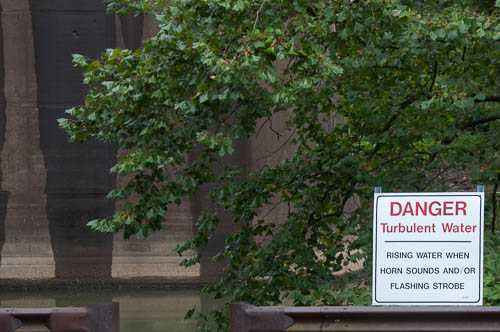
If you access the Tunnelview Historic Site through the entrance to Conemaugh Lake National Recreation Area, you will see this fantastic sign:
Drunk Elephant
Here- at the Tunnelview Historic Site – you will find a small pavilion, primitive restroom, parking lot, and canoe put-in. You will also see remains of the Pennsylvania Mainline Canal. This is where Jonathan and I put-in when we kayaked to Saltsburg twice.
Oh! I have to tell you about the FIRST time Jonathan and I kayaked from here:
We parked here at the Tunnelview Historic Site. We paddled downstream six miles, almost to Saltsburg. We stopped for lunch. It was June, and the current didn’t “seem” all that strong. As per our plan, we set off to paddle upstream back to our car.
Hey, I think that we have been paddling next to that same rock for the past ten minutes. What the – when did the current get that strong?
That’s right – we couldn’t paddle upstream. We portaged our kayaks upriver for a good part of the return trip. We smelled a dead animal rotting in the water. Jonathan didn’t tell me about the snakes that swam past us because snakes scare me. I worried that we wouldn’t get back to our car before the sun set, that we would have to spend the night in the woods, and that somebody would find our car and report us as missing on the river. As I pulled my kayak over the stones on the riverback, I fantasized about the search party that would be sent after us, about our faces all over the news. (We did get back to our car and get the kayaks loaded right before it got dark.)
In hindsight, we should have paddled to Saltsburg, then hired the canoe outfitter in Saltsburg to take us upriver to our car. We talked about doing this when we realized that we couldn’t paddle against the current. Why didn’t we? Because we’re stubborn.
On our second trip, we parked in Saltsburg and let the outfitter drive us to the put-in at the Tunnelview Historic Site. Then we paddled downriver to our car. Much better.
Life is easier when we aren’t stubborn.
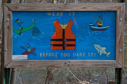
Here is the sign that SHOULD have tipped us off that the Conemaugh River’s current “might” be sorta strong at our put-in spot:
Here’s another important sign:
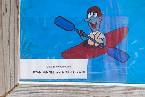
(Here is a close-up of the artist names:)
We haven’t picnicked at Tunnelview or kayaked on the Conemaugh River for a while because we’ve spent so much time this year with the “new” sailboat. However, I really think that you would enjoy your visit to Tunnelview.
As I noted, the remains of the canal and aqueduct at this site were part of the Pennsylvania Mainline Canal, which worked in a system with the Allegheny Portage Railroad. From the 1830’s – 1850’s, this system hauled boats over the Allegheny Mountains. Pennsylvania paid to construct the entire thing. Then, after about only two decades, the system became obsolete! I WILL blog about this on some future day.
(This is a redux from the blog that I created with my husband Jonathan, www.jennyandjonathangetmarried.com. I will shortly pull more of my favorite stories out from the crypt. I want to share more of my favorite moments and places with you fantastic readers.)
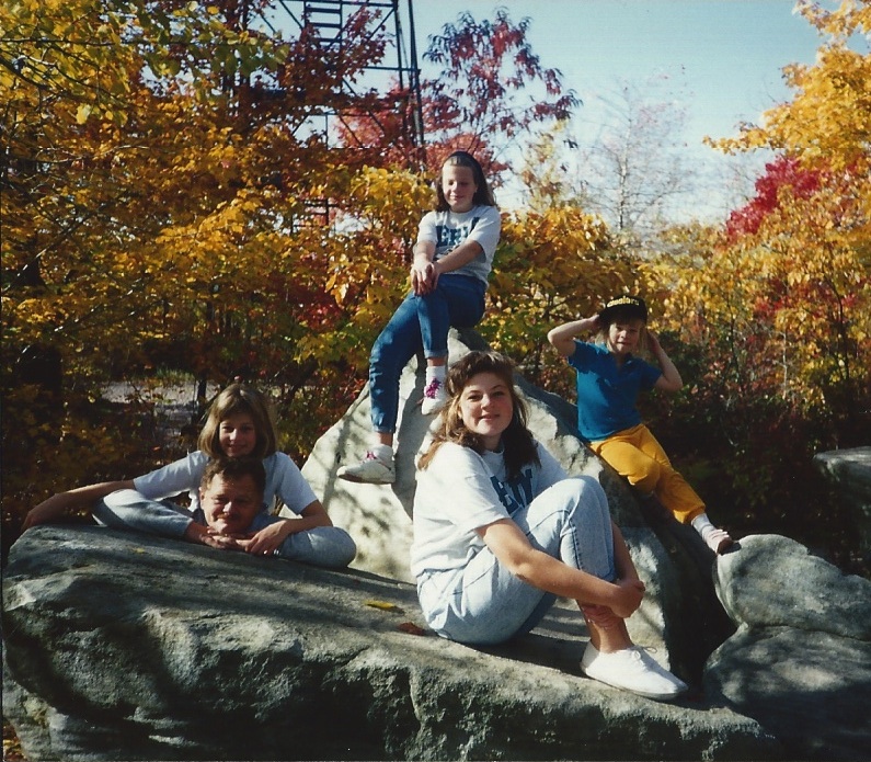
Mount Davis, Somerset County, Pennsylvania. Early 1990’s. (Photo: Shirley Katherine Gaffron)
1.) Mount Davis is the highest point in Pennsylvania.
2.) The tallest rock shown in the above photo marks Pennsylvania’s true high point. This rock includes a metal plate noting this. In the above photo, my sister K. sits at the very top of this rock.
3.) A 50 foot metal observation tower / fire tower sits a few feet away from this rock that marks the true high point.
Planning Your Trip to Mount Davis:
1.) Mount Davis belongs to Forbes State Forest. Here are the maps from PA DCNR.
2.) Jonathan and I sometimes come up here to escape Pittsburgh-area heat waves. Keep that in mind when you choose clothing for your trip.
3.) You can travel between the High Point and the Mount Davis Picnic Area by car or by foot on a CCC trail. The picnic area includes picnic tables, a pavilion, and a primitive restroom. However, note that there is no place to shop or buy gas on the summit. If you intend to travel south from Meyersdale to Mount Davis, note that Meyersdale is the closest place where you can purchase any of these things.
Watch your speed and watch out for Amish buggies. Be especially careful on Sundays. This area hosts many Amish farms, and the families who live here travel for Sunday worship. The first time that I brought Jonathan to Mount Davis, we missed the sign for our turn-off from Route 219 in our diligence regarding the buggies.
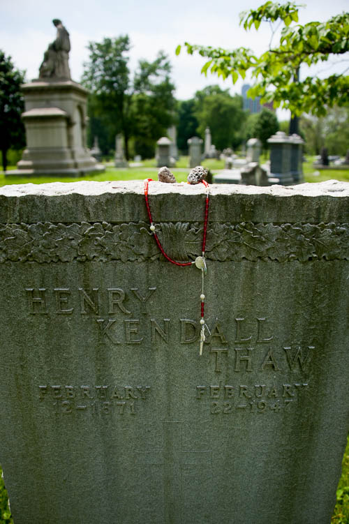
Harry K. Thaw’s Grave, Allegheny Cemetery, Pittsburgh, PA. May, 2019. (Photo: Jenny Gaffron Woytek)
A few months ago, I blogged about the time that Harry K. Thaw shot Stanford White over White’s relationship with Thaw’s wife, Evelyn Nesbit. (Thaw was from Pittsburgh, and Nesbit was born in Tarentum, PA, although the two of them met in New York City.)
I didn’t put the rosary on this grave. I don’t know who put the rosary on the headstone.
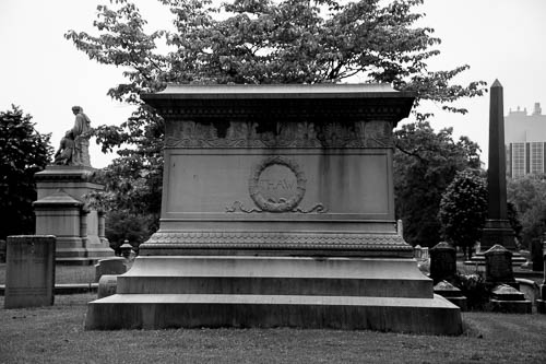
Here is the marker for the Thaw family plot:
Thaw Family Plot, Allegheny Cemetery, Pittsburgh, PA. May, 2019. (Photo: Jenny Gaffron Woytek)
If you want to hear a podcast or two about Evelyn Nesbit, “The Girl in the Red Velvet Swing,” and Thaw’s murder of White, check out these podcast episodes:
2.) Then, an episode of the podcast My Favorite Murder talked about this in episode 136 and heavily “cited” Criminal. (In my opinion, the bulk of the My Favorite Murder host’s “research” consisted of her listening to the Criminal episode! This is merely my personal opinion, though.)
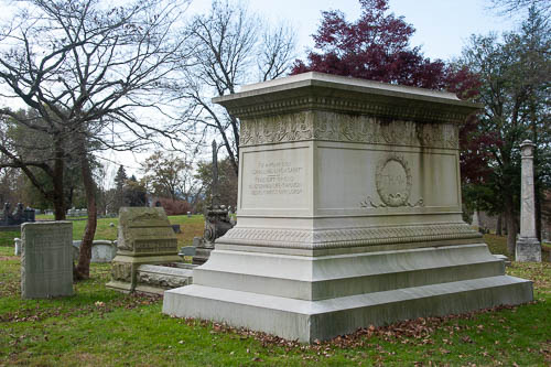
Thaw Family Plot, Allegheny Cemetery, Pittsburgh, PA. November 10, 2019. (Photo: Jenny Gaffron Woytek)
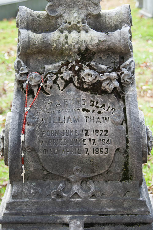
William Thaw Grave, Allegheny Cemetery, Pittsburgh PA. November 10, 2019. (Photo: Jenny Gaffron Woytek)